FAQs
Find the answers to your questions in the FAQs (frequently asked questions).
What does the offer include?
Access to download is free and direct, no account creation is required (no registration to a shop, an application …). The Guide Apacheta offer includes :
- The guidebook in PDF format
- GPS track in GPX and KMZ formats
- Free updates for 6 months
Every validated order is confirmed by email. You will receive an automatic confirmation email detailing the order and containing links to download the digital books. These links are valid for a period of 180 days within the limit of 5 downloads, starting from the the order (see Terms & conditions).
Using of guides
- How do I print the guides properly?
- What do GPX and KMZ formats mean?
- How to use GPS files?
- How to read the step tables?
- What do the # with the names?
- How accurate are the GPS files?
- What are the meanings of the pictograms?
- How to benefit from updates?
- How can I resolve a problem with the GPS track display?
Realization of guides
- Who makes these guides?
- How the running times are calculated?
- How the cards are made?
- How tracks and waypoints are made?
- How GPS readings are taken?
- How altimeter readings are measured?
– Using of guides –
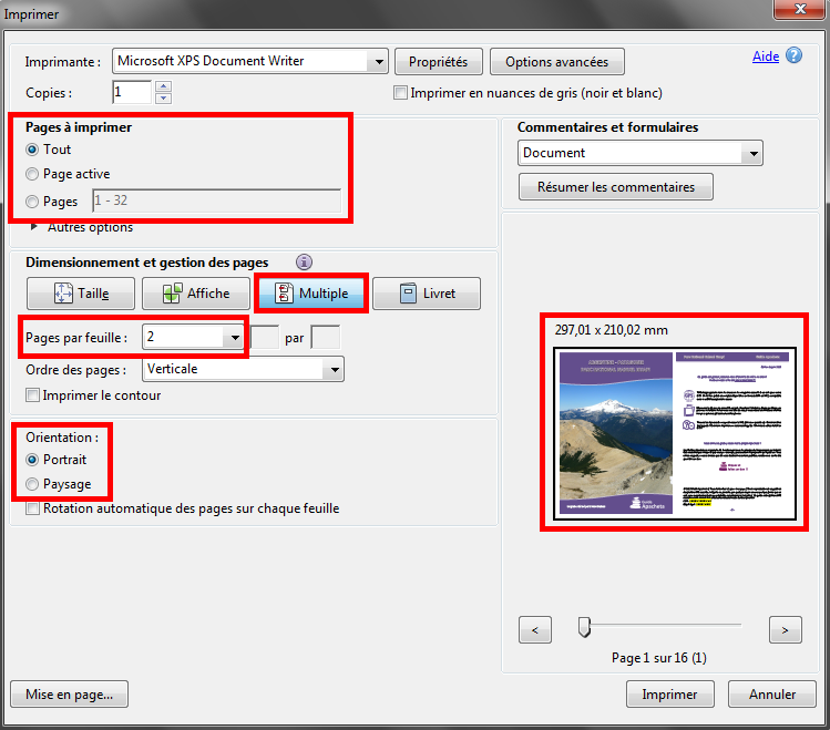
1. How do I print the guides properly?
The format of the guides is 148x210mm, half A4 (297x210mm), so that two pages of the book can be printed on a single A4 sheet. Open the document with the free Adobe Reader software, then go to the print window (File/Print).
- Choose the pages you want to print « All » or « Pages » and enter the page numbers.
- Click on the « Multiple » button to print 2 pages on 1 sheet.
- Select « 2 » from the « Pages per Sheet » drop-down menu.
- Make sure that the orientation is in « Portrait » (vertical) mode.
- Check before printing that the print size is 297x210mm and that 2 pages appear in the preview.
2. What do GPX and KMZ formats mean?
Two GPS file formats are provided with the guides.
- GPX format: This format is for your GPS or smartphone/tablet. See « How do I use GPS files? ».
- KMZ format: This format is intended to have a preview of the route on your computer. To do this, use the free Google Earth software.
3. How to use GPS files?
You can use the file in GPX format either with a GPS or with a smartphone/tablet preferably equipped with a GPS receiver.
- With a GPS: Transfer the file in the usual way to your device and go to the « track » and « waypoint » tabs to view them. Each brand has its own method of sending/extracting files to the device, so refer to your GPS owner’s manual.
- With a smartphone/tablet: Use a mapping application such as OsmAnd for Android (free version limited to 10 maps). It has the advantage of being able to easily download OpenStreetMap maps to the device for offline viewing free of charge.
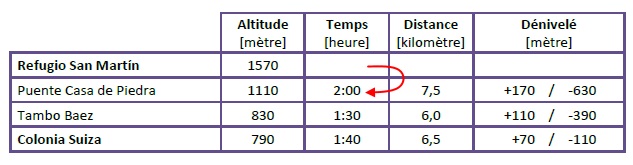
4. How to read the step tables?
The tables are a synthesis of the different stages of the day. They show the name of the place, its altitude and the time, the distance and the difference in altitude between it and the previous stage. For example, with the table below, from the « Refugio San Martín » it takes 2 hours of walking to reach the « Puente Casa de Piedra ». Then from « Puente Casa de Piedra », it takes 1:30 of walk to get to « Tambo Baez ».
5. What do the # with the names?
Each bold name preceded by a #, such as #Refugiul Viștea Mare, corresponds to a waypoint. This allows a better association between the paper book and the GPS file provided.
6. How accurate are the GPS files?
The accuracy of a GPS is about 5 to 10 meters, when the reception is good. In addition, there is a margin of error when taking readings, even if everything has been done to reduce them to a minimum (see: « How are tracks and waypoints made? »). No matter how accurate a GPS file is, there will always be a margin of error, so don’t follow it blindly.
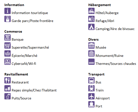
7. What are the meanings of the pictograms?
8. How to benefit from updates?
During the 180 days following the date of purchase of your guide, you can benefit from free updates, within the limit of 5 downloads. Compare the issue date on your guide to the one indicated on the site. If it is older, re-download the guide and GPS track from the links provided in your order confirmation email.
9. How can I resolve a problem with the GPS track display?
If you encounter a problem when importing the GPS track, you can consult the tutorial « Problem displaying GPS track » to help you load it correctly.
– Realization of guides –
1. Who makes these guides?
The on-site surveys, the writing of the guide, the design of the GPS files are done to date by the same person, Simon Dubuis founder of Guide Apacheta. For more information, please refer to the page « Author ».
2. How the running times are calculated?
Walking times were estimated on the ground, according to the difficulty of the terrain, the tiredness of the previous stage… Then, they were refined with the method usually used in hiking: 300 metres/hour uphill, 400 metres/hour downhill, 4 kilometres/hour on flat ground.
3. How the cards are made?
The map backgrounds are from OpenTopoMap royalty free images. The trek routes were assumed to these, as well as pictograms. The city maps are made with MapStack.
4. How tracks and waypoints are made?
After several readings of the route in the field, in order to compensate for GPS inaccuracies and errors, the tracks and waypoints are redrawn by hand on GoogleEarth. The different data collected are cross-referenced to obtain the most accurate tracks and waypoints possible..
5. How GPS readings are taken?
In order to compensate for the impressions, all routes were surveyed with multiple Garmin eTrex 30 GPS (sometimes a second GPS of a different model is associated with the surveys). This GPS allows a high degree of accuracy in the readings, as it has dual satellite reception of GPS (North American system) and GLONAS (Russian system). It is also compatible with the SBAS geo-positioning correction system, which includes the WAAS (North and Central America), EGNOS (Europe) and MSAS (Japan) systems.
6. How altimeter readings are measured?
The altitudes displayed in the guides are the official altitudes of the places (those indicated on the maps for example), i.e. those measured during route surveys. For tracks and waypoints, they are taken from the DEM (Digital Elevation Model) provided by NASA, which measures all the altitudes of the planet, with an accuracy of about 30 meters, depending on the location. For this reason, there can sometimes be a difference between an altitude indicated in a guide and its GPS file.